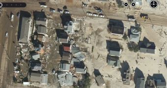
Microsoft’s Bing map solution has been updated with a new Hurricane Sandy app supposed to provide users with a detailed view of the damages caused by the floods.
The high-resolution imagery is available for all users of the Bing Maps service and can be easily loaded in any browser installed on your machine.
“Once weather permitted, Keystone Aerial Surveys, one of our Global Ortho flying partners, acquired over 5,368 sq km of striking high-resolution aerial imagery along the New York and New Jersey coastlines,” Microsoft explained on the Bing blog.
If you wish to load the Hurricane Sandy app, go over to Bing Maps, click on “Map apps” and hit the “Newest” filter option. Choose “Hurricane Sandy” and wait for a few seconds, as the app should automatically zoom in to display the high-resolution imagery with the affected coastlines.

 14 DAY TRIAL //