Simple-to-configure program that helps you download Google maps, combine the small tiles into a larger image, as well as grab just a single photo. #Google Map #Download Image #Combine image #Downloader #Map #Image
Google Maps Images Downloader is a very simple software solution that can automatically download Google Maps and create large images that can be stored on the computer.
Basically, the program downloads small tile images based on the coordinates you provide and then combines them into a single and larger photo.
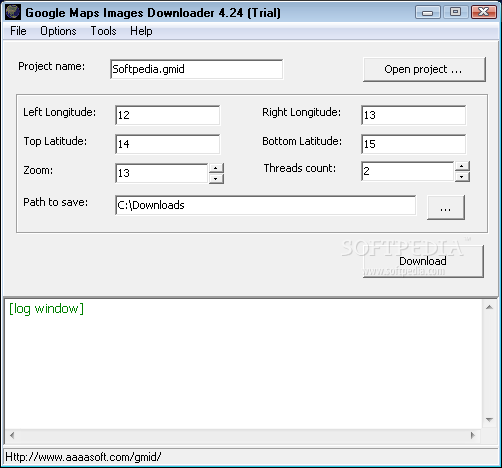
The interface, which otherwise is pretty easy to use, prompts the user to provide left and right longitude, as well as top and bottom latitude, but also to define zoom level and thread count. Just pick the path to save and you're ready to go.
Once the files land on your computer, you have the option to combine the images and thus create a large photo, but Google Maps Images Downloader also provides some other extras.
For instance, there's a dedicated tool to download just a single image, but also a so-called “Satellite Images Viewer” to check the coordinates you've provided in the main window.
The “Options” menu allows you to set up the application to work with a proxy server, choose the file naming format, and define some default settings such as zoom level, threads count and path to save the files.
It's no surprise that Google Maps Images Downloader runs on low computer resources and should be able to run just fine provided that it's connected to the Internet in order to download data.
As a conclusion, Google Maps Images Downloader is a handy software solution that serves its purpose quick and easy.
Google Maps Images Downloader 4.322
add to watchlist add to download basket send us an update REPORT- runs on:
- Windows All
- file size:
- 980 KB
- filename:
- gmid_setup.exe
- main category:
- Internet
- developer:
- visit homepage
4k Video Downloader

Windows Sandbox Launcher

calibre

Context Menu Manager

Zoom Client

Bitdefender Antivirus Free

IrfanView

ShareX

7-Zip

Microsoft Teams

- ShareX
- 7-Zip
- Microsoft Teams
- 4k Video Downloader
- Windows Sandbox Launcher
- calibre
- Context Menu Manager
- Zoom Client
- Bitdefender Antivirus Free
- IrfanView