Efficiently Plan, Document & Coordinate. #Infrastructure design #GIS map management #3D map designer #3D map #GIS map #Infrastructure
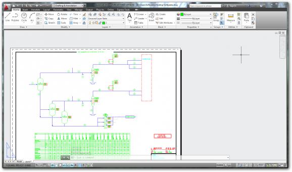
Autodesk Infrastructure Design Suite Standard, ideally suited for GIS and planning professionals, offers a familiar AutoCAD software workflow with planning, foundational design, and coordination capabilities in a single economical and convenient package.
Better understand existing conditions with integrated CAD and GIS data, coordinate with other engineering disciplines, and more effectively maintain civil and infrastructure assets.
Plan projects with greater confidence and help inform critical design decisions earlier in the process. Broad access to CAD and GIS mapping data helps to develop a better understanding of existing conditions. And GIS mapping and analysis capabilities can help to gain insight into project feasibility and impact.
Autodesk Infrastructure Design Suite Standard includes: · AutoCAD · AutoCAD Map 3D · Autodesk Storm and Sanitary Analysis · Autodesk Navisworks Simulate Autodesk Infrastructure Design Suite Standard comes with all the needed tools for planning, coordinating and managing GIS information.
System requirements
- XP - 1.6 GHz or Higher Intel Pentium 4 or AMD Athlon Dual Core with SSE2 technology
- Vista or Windows 7 - 3.0 GHz or Higher Intel Pentium 4 or AMD Athlon Dual Core with SSE2 technology
- 2 GB RAM (4 GB RAM Recommended)
- Basic Graphics - Display adapter capable of 24-bit color
- Advanced Graphics - 256 MB DirectX 10 capable graphics card with Shader Model 3
- 1280x1024 with True Color display resolution
- 15 GB of Free Space
Limitations in the unregistered version
- 30 days trial
What's new in Autodesk Infrastructure Design Suite Standard 2013:
- Better Utilize Imagery:
- With the addition of AutoCAD Raster Design 2013 software, powerful raster editing and raster-to-vector conversion tools are now available within AutoCAD-based software, helping you use or reuse scanned paper drawings, maps, satellite images, aerial photos, and similar digital data in the course of your design projects. When used with AutoCAD Map 3D 2013, AutoCAD Civil 3D® 2013, and AutoCAD Utility Design 2013 software, AutoCAD Raster Design enables you to merge, crop, georeference, and export imagery for use in Autodesk Infrastructure Modeler 2013 software and other applications; and use readily available multispectral satellite imagery to help show vegetation, land cover, and environmental information to aid planning and design decisions.
- Explore Tomorrow’s Infrastructure Today:
Autodesk Infrastructure Design Suite Standard 2013
add to watchlist add to download basket send us an update REPORT- runs on:
-
Windows 8 32/64 bit
Windows 7 32/64 bit
Windows Vista 32/64 bit
Windows XP 32/64 bit - file size:
- 94 MB
- main category:
- Science / CAD
- developer:
- visit homepage
Bitdefender Antivirus Free
7-Zip
paint.net
IrfanView
calibre
Windows Sandbox Launcher
Zoom Client
ShareX
Microsoft Teams
4k Video Downloader
- ShareX
- Microsoft Teams
- 4k Video Downloader
- Bitdefender Antivirus Free
- 7-Zip
- paint.net
- IrfanView
- calibre
- Windows Sandbox Launcher
- Zoom Client
