A professional tool designed to calculate world-wide positioning based on the longitude/latitude system and executes coordinate transformations. #Coordinate Transformation #Datum Shift #Receive Coordinate #Coordinate #Longitude #Latitude
TRANSDAT is a lightweight tool that has been designed to help those who need to transform spatial data from one coordinate reference system to another. The software is also capable of changing the data structure simultaneously with making the aforementioned transformations.
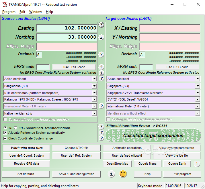
The application offers various methods of transforming worldwide coordinates, courtesy of support for various Reference Systems for European countries (both EU and non-EU) or for the United States and Canada. It also features NTv2 grid file supported coordinate transformations.
The utility provides users with the possibility to define their coordinates in more than one manner, such as by using either worldwide systems or country-specific ones. They can use Helmert or Molodenski (Bursa / Wolf) parameters for this action.
The tool enables users to define their own coordinate or reference systems, while also offering support for the use of EPSG codes for these systems.
Users can enter coordinates either by typing them manually, or by loading them from a file. To make this operation easy, TRANSDAT comes with support for formats such as Text, dBase, or ArcGenerate. There is also an included Shape Viewer for opening ArcShape files.
The utility comes with a programmable GPS interface that offers support for reading coordinates from a GPS antenna connected to a laptop or notebook, and can also run on a network. Moreover, it can perform batch processing actions.
TRANSDAT enables users to view coordinates in Google Maps / Earth and OpenStreetMap with a simple mouse click, via a set of buttons conveniently placed on its main window.
The software can perform arithmetic operations and also allows users to choose an NTv2 file to work with, or to view the log file. User-defined configurations can be saved for later access.
TRANSDAT can easily prove a helpful tool for professionals, providing them with the possibility to perform coordinate transformations fast and easy for use in the reference system of their choosing.
What's new in TRANSDAT 27.29:
- Corrections regarding the use of user-defined coordinate systems.
TRANSDAT 27.29
add to watchlist add to download basket send us an update REPORT- runs on:
-
Windows NT
Windows 11
Windows 10 32/64 bit
Windows 8 32/64 bit
Windows 7 32/64 bit
Windows Vista 32/64 bit
Windows XP
Windows 2K - file size:
- 5.4 MB
- filename:
- transdat.zip
- main category:
- Maps / GPS
- developer:
- visit homepage
calibre

Context Menu Manager

Bitdefender Antivirus Free

Zoom Client

7-Zip

Microsoft Teams

IrfanView

Windows Sandbox Launcher

ShareX

4k Video Downloader

- Windows Sandbox Launcher
- ShareX
- 4k Video Downloader
- calibre
- Context Menu Manager
- Bitdefender Antivirus Free
- Zoom Client
- 7-Zip
- Microsoft Teams
- IrfanView