14 DAY TRIAL //
 Probably one of the most successful Google products, Google Earth puts the world at the reach of your fingertips in digital form. It has come a long way since the previous Softpedia review.
The tool enriches the traveling experience by letting people navigate satellite maps, visit placemarks and organize tours in 3D, put together routes using drawing and measuring tools, as well as explore the outer space, including the Moon and Mars.
The full application can be downloaded via Google Updater which requires users to remain online throughout the installer. Additional libraries or components are not required.
Freely exploring Earth and other places
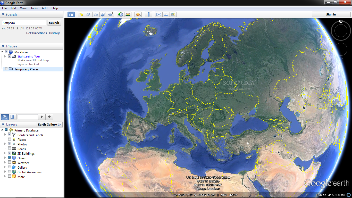
The feature-rich program can be better explored by maximizing the main window or entering full screen mode. Earth is displayed on the largest portion of the panel, where navigation is possible through mouse buttons, on-screen controls, and even keyboard for increased accuracy; the toolbar and sidebar can be hidden. Depending on the mouse cursor's current position, the status bar shows the coordinates and elevation.
One of the aspects that make Google Earth a sought-after application lies in the user's ability to add their own placemarks, polygons, paths, and image overlays to custom locations. These buttons are accessible from the toolbar, and properties include a name, coordinates, description with links and images, label and icon color, scale and opacity, view mode (e.g. range, heading, tilt, date and time), and altitude (e.g. clamped to ground, absolute).
Measuring distances is done with a ruler, and all you have to do is mark point A, B, and others with the mouse cursor, and select the length unit. The current view can be saved as a screenshot or exported to the applications native KML file format (to open the current view in Google Earth), printed, or accessed in Google Maps.
Sidebar options
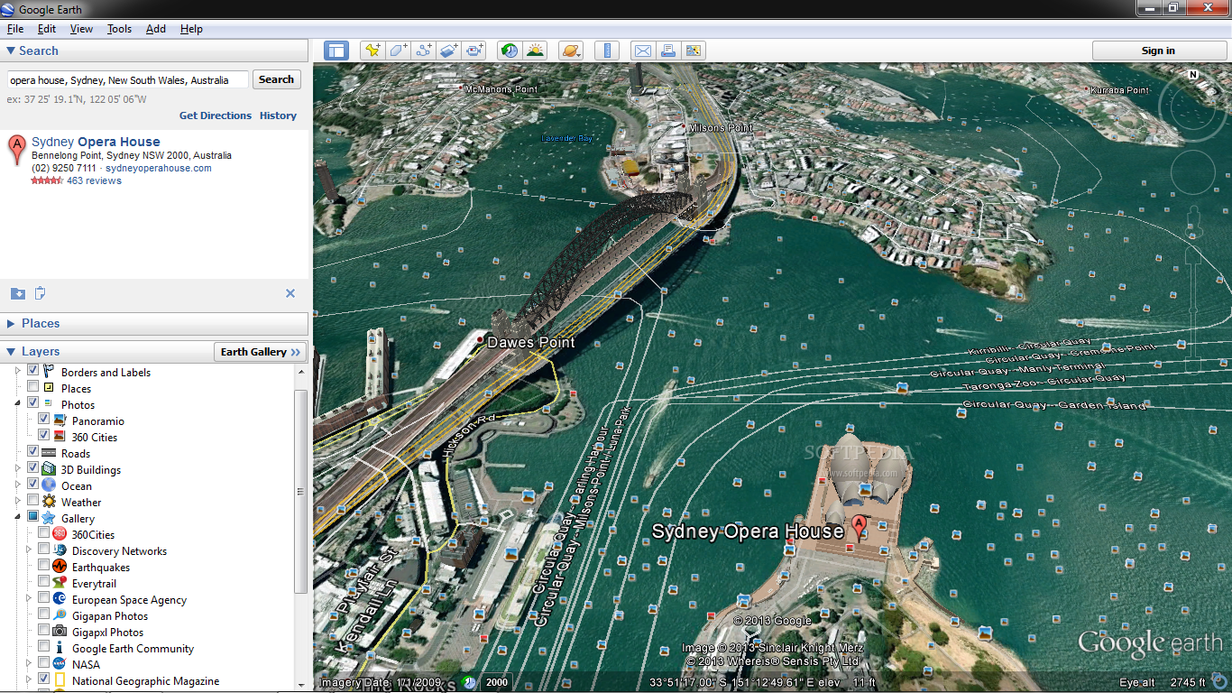
The most useful tool of Google Earth is represented by a search function that you can use to find locations and buildings by name or coordinates. If you're planning a sightseeing tour, then you can get directions from one spot to another. Text strings are recorded to a search history list. Landmarks can be quickly accessed as well, such as The Eiffel Tower, The Grand Canyon, Sydney, and The Titanic, or you can start a virtual tour to visit all points of attraction.
Map layers can be turned on and off, making Google Earth highly customizable. These focus on borders and layers, places, photos (Panoramio, 360-degree cities), roads, 3D buildings (photo-realistic, gray, trees), ocean (e.g. shipwrecks, dead zones, animal tracking), weather (clouds, radar, conditions and forecast, ocean observations, information), Earth gallery (e.g. 360-degree cities, earthquakes, NASA, National Geographic Magazine, volcanoes), and others. More featured maps are available online.
If you are looking for a unique exploration technique, feel free to enter flight simulation mode and fly through the world freely by picking an aircraft and start position, as well as enable joystick support if available.
Program options
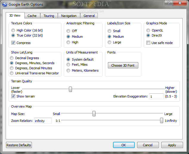
The 3D viewing mode can be customized in terms of texture color (high or true color, compression), anisotropic filtering (off, medium, high), labels/icon size, graphics mode (OpenGL, DirectX, safe mode), latitude and longitude display (e.g. Universal Transverse Mercator), measurement unit (e.g. feet, miles), 3D font, terrain quality, and overview map.
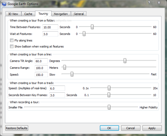
Furthermore, the memory and disk cache size can be set and cleared. You may hide tooltips, disable building highlighting, use a Gmail account when sending email, allow access to local files and personal data in regard to placemark balloons, and so on. Settings can be restored to their factory values.
The Good
The extremely interactive environment can make anyone prone to spending hours getting lost through Google Earth, since it is educational and, quite frankly, addictive. It is free of charge, available to everyone.
The Bad
CPU and RAM resources consumption is generally high, and some environment features take a while to load.