A mapping control powered by the combination of Microsoft’s Silverlight 2.0 platform and the DeepZoom (MuliScaleImage) control. #Mapping Control #Control Map #Silverlight Control #Silverlight #Control #Map
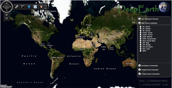
DeepEarth was designed to be a mapping control powered by the combination of Microsoft’s Silverlight 2.0 platform and the DeepZoom (MuliScaleImage) control. At its core, it builds on these innovative technologies to provide an architecture for bringing together layers for services, data providers, and your own custom mapping elements together into an impressive user experience.
Also featured are in depth examples of how you can leverage Virtual Earth Web Services to take advantage of advanced GIS service functionality. This is what you need to get an interactive, native Silverlight 2.0, map into your application today.
DeepEarth supports the Virtual Earth Web Service (VEWS) for tile layers, geocoding (finding an address), reverse geocoding (getting an address from a point on the map) and routing.
System requirements
What's new in DeepEarth 1.1:
- Contains several updates to known bug fixes and issues
- General Cleanup from feedback on 1.0
- Help Documentation
DeepEarth 1.1
add to watchlist add to download basket send us an update REPORT- runs on:
-
Windows 2003
Windows Vista
Windows XP
Windows 2K - file size:
- 231 KB
- filename:
- DeepEarth.Bin.zip
- main category:
- Programming
- developer:
- visit homepage
7-Zip

Microsoft Teams

Zoom Client

calibre

Context Menu Manager

IrfanView

4k Video Downloader

Windows Sandbox Launcher

Bitdefender Antivirus Free

ShareX

- Windows Sandbox Launcher
- Bitdefender Antivirus Free
- ShareX
- 7-Zip
- Microsoft Teams
- Zoom Client
- calibre
- Context Menu Manager
- IrfanView
- 4k Video Downloader