An open-source photo geotagger that is able to read and modify the location-related data present within an image's EXIF in an easy manner. #Geotag Editor #Change Geodata #Image Location #Geodata #Geotag #Image
Thanks to the more advanced camera systems of today, your photos getting automatically geotagged is almost a given. Unless you’ve disabled the feature, most phones will automatically record location data upon clicking the shutter button.
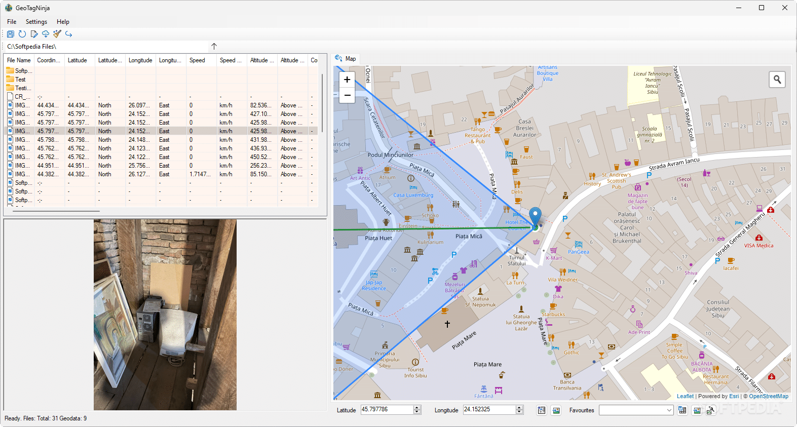
If you’re interested in finding out more about your geotagged shots, or are looking to modify or add some additional information, then GeoTagNinja should be an apt tool for the job. It’s easy and convenient to use, thanks to an interface that features a map that lets you see the precise location for each of your shots.
As stated above, it shouldn’t take long before you attune to working with the program. Specifying the folder where you store your photos is the first step, and most things will come naturally after that.
Clicking a photo will reveal its location data on the map based on its latitude and longitude. Depending on your camera, this location may be more or less accurate. Either way, GPS data can be modified via the Edit Data menu, which lets you manually configure the latitudinal and longitudinal values. This also enables you to set location data for photos that hadn’t previously been geotagged.
Batch geotagging operations can be carried out through the software in an easy way. Select the photos you wish to modify, then bring up the Edit Data menu to manage their data. To apply a photo’s information to others, you’ll have to use the Set current values for all images selected for editing.
When doing so, you’ll have to decide on the specific data you want to paste. This can include any or all GPS and location data chosen by you, as well as time zone and date-related information.
Connecting with a GeoNames account will unlock some geocoding functionalities, one of which will enable you to get toponomy info for your stills.
GeoTagNinja is a software solution that should serve users well. It enables various geodata operations to be carried out more comfortably. The batch editing functionality is the highlight in my view, but the program obviously has other qualities that may be equally as important, if not more, for you.
What's new in GeoTagNinja Build 8834 [20240309]:
- NEW & UPDATED:
- Paste coordinate-pair string from clipboard into Edit Form (see readme about this or the tooltip in the Edit Form) #100
- Added a button to the Edit Form to move to the next image when there's a multi-selection (Apply & Move to Next) [also #100]
- Bumped exifTool to v12.77
GeoTagNinja Build 8834 [20240309]
add to watchlist add to download basket send us an update REPORT- runs on:
-
Windows 11
Windows 10 32/64 bit
Windows 8 32/64 bit
Windows 7 32/64 bit - file size:
- 34.9 MB
- filename:
- GeoTagNinja_Setup.msi
- main category:
- Multimedia
- developer:
- visit homepage
Context Menu Manager

Windows Sandbox Launcher

ShareX

Bitdefender Antivirus Free

IrfanView

4k Video Downloader

calibre

Zoom Client

7-Zip

Microsoft Teams

- Zoom Client
- 7-Zip
- Microsoft Teams
- Context Menu Manager
- Windows Sandbox Launcher
- ShareX
- Bitdefender Antivirus Free
- IrfanView
- 4k Video Downloader
- calibre