A simple to use application designed to convert raster files from one format to another and change quality parameters, such as raster output bands. #Raster Conversion #Convert Raster #Change Raster #Raster #Conversion #Convert
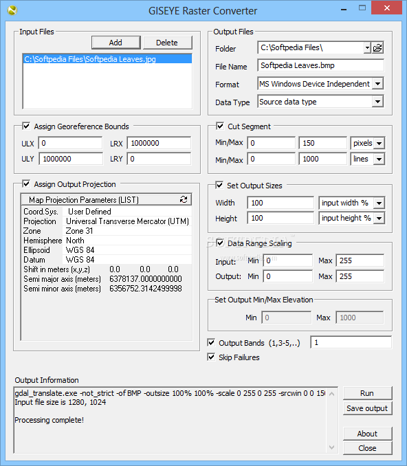
GISEYE Raster Converter is an easy to use application designed to help you convert raster files to multiple other formats and adjust the data type or modify its quality parameters. You may cut out segments from images, as well as assign georeference bounds or output projections.
The software enables you to convert raster files from one format to another, for better handling in other applications or better compression. The software supports multiple input formats and it is capable of converting the files to Info ASCII Grids, DTED Elevation Raster, Erdas Imagine Images, Image Data and Analysis, JPEG 2000, PCI Geomaics Database, PNG, BMP or Vexcel MFF Raster files, just to name a few.
The application can also change the data type that characterises the input file, from source data type to Integer of 16 or 32 bit, as well as Float or Complex Float of 32 or 64 bit.
You may separate a segment from an image by specifying the selected range in pixels and lines. The cut out segment matches the format of the output file, as well as the color mode – RGB, gray scale – and are saved in the destination folder.
The software handles data range scaling and manages custom output raster elevation. Thus, you can control the dynamic range, meaning that you decide the linear contrasting for the output files, by specifying the appropriate values in the minimum and maximum fields.
You may assign georefrence bounds to a raster file, by entering the modified coordinates of the upper left and lower right corners of the raster, in the designates fields. As for assigning output projections, GISEYE Raster Converter does not reproject the input raster, but it can assign a projection in which the coordinates of the output raster are subject to interpretation.
Output projections may be settled from the Map Projection Parameters menu. You may select between List, PROJ4 and WKT representations of the input parameters and modify each row according to your purposes.
GISEYE Raster Converter can process the input files in a matter of seconds and save them as the new format in the destination folder, along with a log file, specifying the output file’s metadata. The software enables you to modify a raster’s quality parameters, assign new attributes or separate pieces of images, or convert the file to formats supported by other applications.
GISEYE Raster Converter 1.3.0.0
add to watchlist add to download basket send us an update REPORT- runs on:
-
Windows 2003
Windows 8
Windows 7
Windows Vista
Windows XP
Windows 2K - file size:
- 17.7 MB
- filename:
- raster-converter-1.3.0.zip
- main category:
- Multimedia
- developer:
- visit homepage
Microsoft Teams

ShareX

calibre

Windows Sandbox Launcher

4k Video Downloader

Bitdefender Antivirus Free

IrfanView

7-Zip

Context Menu Manager

Zoom Client

- 7-Zip
- Context Menu Manager
- Zoom Client
- Microsoft Teams
- ShareX
- calibre
- Windows Sandbox Launcher
- 4k Video Downloader
- Bitdefender Antivirus Free
- IrfanView