Enables you to translate geospatial data between different reference systems, which helps the NOAA improve survey accuracy and obtain better results. #Translate geospatial data #Geospatial data translator #Edit geospatial data #VDatum #Geospatial #Translate
For those with an interest in geography, maps, orienteering and navigation, having an accurate map is vital, but having a chance to help make those maps more accurate is even better. NOAA's Vertical Datum Transformation is a program that allows users to both improve or convert horizontal and vertical DATUM information into a common system.
NOAA's Vertical Datum Transformation is a very large program and, for anyone without a high speed internet connection, downloading the full file will be an issue. Though the download includes very detailed and up-to-date map information, which is necessary for its primary function, it does cause significant problems in taking up space.
The lack of support for any other country limits the use significantly, content patches that can be downloaded separately would solve that issue. Not to mention different downloads for different areas within the USA, would help users manage the size of the application.
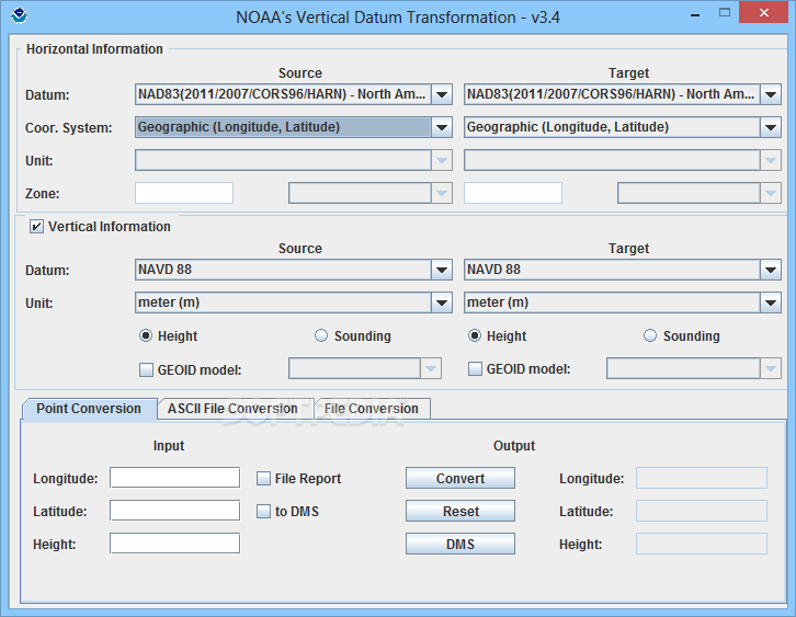
While DATUMs can be quite confusing for some, NOAA's Vertical Datum Transformation goes a long way to make it easy to understand. There is only one main window for the application, with three different tabs to access geographical point conversion, as well as two file conversion tabs, ASCII and ASPRS.
Users only need to enter the longitude and latitude of a specific point, as well as its height in meters. However, the choice to use meters is strange given that locations are restricted to the USA, which mainly uses Imperial measurements. The ability to use feet or meters would be a decent improvement, that would make more sense given the country restriction.
Overall, NOAA's Vertical Datum Transformation is a useful tool that is advanced enough to appeal to those interested in map configuration. That being said, the biggest downside of the application remains the file size. Breaking the file apart into different downloads based on regions would allow users to download the information that is relevant to them, for those who don't have the connection to handle the entire USA reference points.
NOAA's Vertical Datum Transformation 3.7
add to watchlist add to download basket send us an update REPORT- runs on:
- Windows All
- file size:
- 1.8 GB
- filename:
- vdatum_all_20170907.zip
- main category:
- Science / CAD
- developer:
- visit homepage
Microsoft Teams

7-Zip

Zoom Client

Context Menu Manager

calibre

Bitdefender Antivirus Free

Windows Sandbox Launcher

IrfanView

ShareX

4k Video Downloader

- IrfanView
- ShareX
- 4k Video Downloader
- Microsoft Teams
- 7-Zip
- Zoom Client
- Context Menu Manager
- calibre
- Bitdefender Antivirus Free
- Windows Sandbox Launcher