Java tool that helps with geotagging photos by matching date/time information from images with location data from a GPS unit or external map (Google Maps or Google Earth). #Geotag image #Location coordinate #Locate image #Geotag #Asign #Coordinate
Geotag is a lightweight software application whose purpose is to help you geographically tag your images by attaching location information from a GPS unit or map.
This is a Java-based utility so you should previously install the working environment on your computer.
Portability comes with several advantages to your system. You can run the tool by simply opening the EXE file, so the installation process is bypassed. The tool doesn’t leave any entries in your Windows registry.
You may store it on any USB flash drive or other devices and uninstall it by deleting the files that you have downloaded from the Internet.
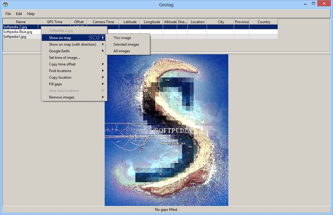
Geotag reveals a plain interface that is divided into two main areas: one is responsible for displaying the geographical information about the uploaded photos, while the other panel shows a preview of the selected image using thumbnails.
Pictures can be added in the working environment using the drag-and-drop support or built-in browse button. For a large collection of photos, you can insert the content of an entire folder to the list.
The application is able to work with JPEG/JPG file format and many RAW camera vendor specific files, such as ARW (Sony), CR2 (Canon), DCR (Kodak), DNG (Adobe), ERF (Epson), MRW (Minolata), NEF (Nikon), and ORF (Olympus).
Geotag is able to reveal information about the name, GPS time, offset, camera time, latitude, longitude, altitude, direction, location, city, province, country, as well as description.
It comes with support for an algorithm that automatically matches GPS data to your photos and makes guesses based on the closest available GPS information.
What’s more, you are allowed to view the selected image or all photos on Google Maps via your default web browser, display a picture on the map with or without description, and reveal a photo in Google Earth.
You may change or correct the location associated with a photo by dragging the marker on the map to the desired position in Google Maps and Google Earth. The changes are immediately mirrored in Geotag.
You are allowed to set the time of the image, copy time offset to all items in the list or only to the selected one, find locations, copy locations to the previous or next picture, all items or only the selected file, save the new locations, remove items from the list, load tracks from GPX file format or GPS, and undo or redo your actions.
If you are not the owner of a GPS unit, the utility can help you assign a location to the photo by dragging the marker on the map and zooming it to give the image a location.
All things considered, Geotag comes with a decent feature pack for geotagging images. You may experience some small delays when it comes to loading thumbnail data in the main window and geotagging photos but this intuitive tool is worthy of all your attention.
What's new in Geotag 0.103:
- Fixed problem using later versions of Exiftool
Geotag 0.103
add to watchlist add to download basket send us an update REPORT- runs on:
- Windows All
- file size:
- 3.1 MB
- main category:
- Multimedia
- developer:
- visit homepage
IrfanView

Context Menu Manager

Windows Sandbox Launcher

calibre

Microsoft Teams

ShareX

Bitdefender Antivirus Free

Zoom Client

7-Zip

4k Video Downloader

- Zoom Client
- 7-Zip
- 4k Video Downloader
- IrfanView
- Context Menu Manager
- Windows Sandbox Launcher
- calibre
- Microsoft Teams
- ShareX
- Bitdefender Antivirus Free